
דוקטורנטים מספרים - Yohai Magen

What can be learned about earthquake physics from satellite images?
Yohai Magen
Supervisors: Prof. Alon Ziv, Dr. Asaf Inbal, and Dr. Gideon Baer (Geological Survey of Israel)
Five out of the ten biggest natural disasters in recorded human history were earthquakes. Today more than ever before, we are under the threat of a major earthquake disaster which could strike one of the modern age megacities such as Istanbul, San Francisco, Tokyo, and other densely populated cities that are situated on the boundaries of tectonic plates. We in Israel also live with the same threat, as the Dead Sea fault stretches along our western border, and it is expected to produce a moderate to large earthquake in the near future. Nonetheless, despite the grave danger posed by earthquakes and the destruction which they wreak, the actual physics that controls their mechanisms are not fully understood.
My name is Yohai Magen and I am a PhD student in the seismologic research group of the geophysics department at the Porter School of Environment and Earth Sciences at Tel Aviv University. In the seismologic research group, we are investigating all the different aspects of earthquakes, from the basic physics that controls their initiation to early warning systems based on machine learning.
Earthquakes occur mainly on tectonic plate boundaries, and their hypocenter, “their origin” ranges from a few to tens of kilometers deep within the earth crust. Therefore, we cannot directly measure an earthquake. My main method is to use remote sensing data named InSAR that measures the earth’s deformation on a centimeter-millimeter scale from 700 kilometers above the ground. From the ground movement data and a physical model, I resolve the earthquake’s source parameters, mainly the movement (slip) that causes the event. After resolving the earthquake’s source parameters by using this model, we can calculate the changes in stress (forces) in the earth’s crust and estimate the probability of nearby faults to produce an earthquake in the future.
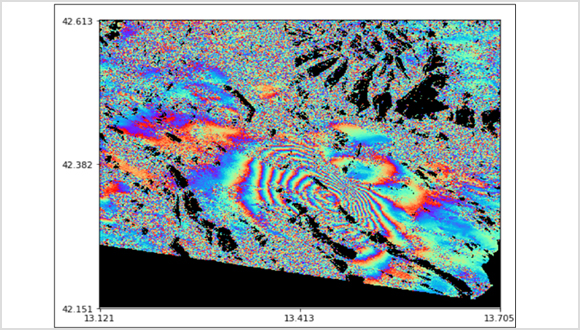
InSAR image of the L’Aquila Italy 2009 earthquake. Changes in color indicate ground movement during the earthquake.