דוקטורנטים מספרים - Leenes Uzan
Improving the assessment of air pollution dispersion employing remote sensing from the surface
Leenes Uzan
Supervisors: Prof. Pinhas Alpert and Dr. Smadar Egert
In this era of heavy industrialization and growing urbanization, the need to mitigate hazardous air pollution exposure and protect our health is unquestionable. Yet, in order to regulate and establish environmental thresholds, a comprehensive understanding of air pollution dispersion processes is crucial. Hi! I'm Leenes Uzan, and I am working under the supervision of Prof. Pinhas Alpert and Dr. Smadar Egert in atmospheric sciences. When I began to pursue my PhD studies, I worked as an environmental engineer, specializing in air pollution. One of the key meteorological parameters governing this dispersion is the planetary boundary layer (PBL) height. In order to assess the extent of air pollution emitted by various sources, there is a need for dispersion models based on the PBL heights. Unfortunately, however, taking such measurements is prohibitively expensive, and thus important data is very scarce. Therefore, the "big idea" of my dissertation is to utilize a cloud-based detection micro-LIDAR, deployed in every airport around the world and in Israel as well, to detect PBL heights at a reasonable cost.
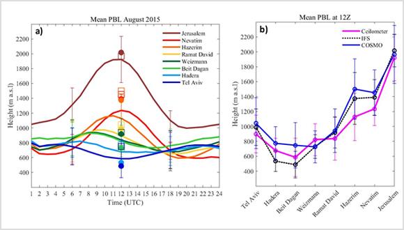
This micro-LIDAR, known as a "ceilometer", provides high resolution attenuated backscatter profiles from ground level up to several kilometers every 15 seconds. The ability to derive the PBL height in this way is not trivial and requires meticulous analysis. Our research offers a first glimpse of the great potential of ceilometers to explore the temporal and spatial evolution of the PBL. Furthermore, ceilometers are an essential validation tool for PBL height estimations derived from high resolution numerical weather models, and thus vastly contribute to our knowledge of air pollution dispersion and risk analysis. Our research is best illustrated by the diagram below:
Figure 1 Above. (a) Mean diurnal PBL height based on all dates available for each site for August 2015 as follows: Jerusalem (830 m a.s.l) - 21 days, Nevatim (400 m a.s.l) - 13 days, Hazerim (200 m a.s.l) - 20 days, Ramat David (50 m a.s.l) - 26 days, Weizmann (60 m a.s.l) - 25 days, Beit Dagan (33 m a.s.l) - 13 days, Hadera (10 m a.s.l) - 16 days, Tel Aviv (5 m a.s.l) - 25 days. Results at 12 UTC from IFS and COSMO models are represented as solid dots and blank squares, respectively. (b) Comparison of PBL heights for 12 UTC where the order of the eight ceilometer cites goes inland following the topographical height a.s.l.


